Georadar Application techniques
- Aerial Georadar Measurements
- Land Georadar Measurements
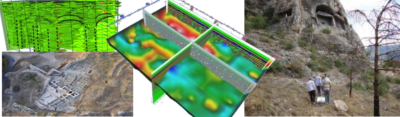
A-) Archaeological Researches:
---------------------------------------------------------------------------------------------------------------
It is possible to determine the depth and architectural structure of the cultural assets hidden underground and model them with 2D and 3D section diagrams. In this way, engineering structures (Buildings, Bridges, Tunnels, etc.) can be easily projected without damaging our hidden cultural assets.
Effective results can be obtained in the direction of excavations and surface surveys for archaeological research.
B-) Solution of Engineering - Geotechnical Problems:
---------------------------------------------------------------------------------------------------------------
- Determining the causes of settlements and deformations in the ground or building,
- Revealing the Landslide and Slip Geometry,
- Determination of the Fill-Bedrock Level,
- Cover thickness in paleo seismological studies, determination of faults, determination of trench excavations,
- Determination of karst cavities and distributions in building site selection,
- Determination of the spread of karstic structures such as potholes,
- Successful results have been obtained in many areas such as jet-grout, injection, compaction quality control studies.
- Revealing the Geological-Geotechnical profile with high resolution in the road-tunnel route selection, determining the weak zones, faults, karstic structures that may be encountered during the production, and creating the appropriate progression pattern will provide great convenience both in terms of time and economy.

C-) Infrastructure Research and Mapping:
---------------------------------------------------------------------------------------------------------------
We carry out the mapping of the locations and depths of underground pipelines by using GNSS systems with RTK performance together.
D-) Mineral Research:
---------------------------------------------------------------------------------------------------------------
It provides great advantages especially in choosing the mirror location of marble fields and determining the direction of progress. In order to determine the block yield, we map the pulp thickness, density of broken cracks and karstic voids by determining 2D and 3D sections and diagrams.
In open gallery businesses or in tunnels; mineral veins can be tracked.
The boundaries of quarries, sand quarries or clay quarries can be determined and reserve estimates can be made.
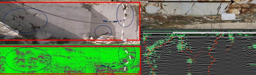
E-) Non-destructive Building Quality Control:
---------------------------------------------------------------------------------------------------------------
It is an undamaged building quality control method that is effectively used to determine the reinforcement in columns and beams, corrosion status, whether there are voids in the concrete, and the foundation type and geometry - depth of the building.
In historical buildings for restoration purposes, the thickness of voids, cracked walls or columns are displayed with 2D or 3D cross-section diagrams.
The quality control of the injection/concrete spread behind the segment or under the precast in the tunnel can be detected without any damage.
In the grouting works to be carried out for waterproofing purposes, it provides the most economical and most effective application opportunity by determining the situation before the injection and making measurements for quality control after the injection application.
In soil improvement methods such as jet-grout and masonry, it is very easy to determine whether there are column sections foreseen in the geotechnical project.

F-) Geological Surveys
---------------------------------------------------------------------------------------------------------------
We get very successful results by using it effectively and successfully in the creation of geological maps and sections, determining the contact boundaries of the units, revealing the fill thickness, and researching the glacial period remains.
G-) In Investigating Environmental Impacts
---------------------------------------------------------------------------------------------------------------
- Investigating the extent of soil pollution,
- Appearance of salt water interference,
- Choosing the location of storage areas such as garbage or investigating whether there are environmental leaks from these storage areas,
- Explosives and ammunition research (UXO)
H-) Road-Airport and Railway Research
---------------------------------------------------------------------------------------------------------------
- Determination of asphalt thickness, sub-base and foundation thickness on highways
- Jamming quality control on highways,
- Determination of the extent and depth of impact of deformations on highway and airport runways
- Determination of ballast pollution and thickness in railways
We are proud to be the solution partner of you, our valued customers, with our experienced staff of more than 30 years in underground exploration.